|
Central and Southcentral Mountains
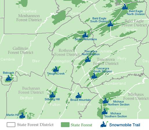
Click on the snowmobiler to pull up the map and download a printable copy. Trails are listed alphabetically below.
Babcock
Details: For details on the Forest, and its 80 miles of snowmobile trail, visit the DCNR page for Gallitzin State Forest. Snow conditions may be found at https://www.apps.dcnr.state.pa.us/forestry/snowmobile/central.aspx
Grooming/Joint Use Roads: Gallitzin State Forest, District 6, encompasses 13.1 miles of joint use road. At this time only Buffalo Road has been posted for possible plowing due to gas or timber operations.See snowmobile trails in Somerset
Location: Babcock Snowmobile Trail is located within Gallitzin State Forest, Somerset County. The Forest makes up part of the Central Region.
Bald Eagle North
Details: For details on the Forest, and its 474 miles of snowmobile trail, visit the DCNR page for Bald Eagle State Forest.
Snow conditions may be found at https://www.apps.dcnr.state.pa.us/forestry/snowmobile/central.aspx
Grooming/Joint Use Roads: Bald Eagle State Forest, District 7, encompasses 290.4 miles of joint use roads, with the following being scheduled for possible plowing due to gas or timber operations:
Kratzer Trail – part of the Sand Mt. shared use trail
Mountain Church Road
Spruce Run Road
Treaster Valley RoadSand Mountain Rd (South)
Siglerville/Manheim Pike
Strong’s Improvement RoadLocation:
Bald Eagle North Snowmobile Trail is located within Bald Eagle State Forest located in Union and Centre Counties – Central Pennsylvania. The Forest makes up part of the Central Region.
Broad Mountain
Details: For details on the Forest, and its 80 miles of snowmobile trail, visit the DCNR page for Michaux state forest.
Snow conditions may be found at https://www.apps.dcnr.state.pa.us/forestry/snowmobile/central.aspx
Grooming/Joint Use Roads: Buchanan State Forest, District 2, encompasses 56.5 miles of joint use roads, with Bark Road and Jerry Road being scheduled for possible plowing due to gas or timber operations:
Location:
The Broad Mountain Snowmobile Trail is located within Buchanan State Forest, in Franklin County. The Forest makes up part of the Central Region.
Martin Hill
Details: For details on the Forest, and its 80 miles of snowmobile trail, visit the DCNR page for Buchanan State Forest. Snow conditions may be found at https://www.apps.dcnr.state.pa.us/forestry/snowmobile/central.aspx
Grooming/Joint Use Roads: Buchanan State Forest, District 2, encompasses 56.5 miles of joint use roads, with Bark Road and Jerry Road being scheduled for possible plowing due to gas or timber operations.
Location: The Martin Hill Snowmobile Trail is located within Buchanan State Forest in Bedford County. The Forest makes up part of the Central Region.
Michaux North
Details: For details on the Forest, and its 80 miles of snowmobile trail, visit the DCNR page for Michaux state forest. Snow conditions may be found at https://www.dcnr.state.pa.us/forestry/snowmobile/central.aspx.
Grooming/Joint Use Roads: Michaux State Forest, District 1, encompasses 44.8 miles of joint use roads. The following have been scheduled for possible plowing due to gas or timber operations:
Birch Run Road
Lindsay Lot Road
Milesburn Road
Piney Mountain Ridge Road
Rattlesnake Run Road
Sand Road
Stillhouse Hollow Road
Swift Run Road
Wirt Road
Woodrow Road – Chickadee Trail
Location: Michaux Northern Section Snowmobile Trail is located within Michaux State Forest, in Adams, Cumberland and Franklin Counties. The Forest makes up part of the Central Region.
Michaux South
Details: For details on the Forest, and its 80 miles of snowmobile trail, visit the DCNR page for Michaux State forest. Snow conditions may be found at https://www.dcnr.state.pa.us/forestry/snowmobile/central.aspx.
Grooming/Joint Use Roads: Michaux State Forest, District 1, encompasses 44.8 miles of joint use roads. The following have been scheduled for possible plowing due to gas or timber operations:
Birch Run Road
Lindsay Lot Road
Milesburn Road
Piney Mountain Ridge Road
Rattlesnake Run Road
Sand Road
Stillhouse Hollow Road
Swift Run Road
Wirt Road
Woodrow Road – Chickadee TrailLocation: Michaux Southern Section Snowmobile Trail is located within Michaux State Forest, in Adams and Franklin Counties. The Forest makes up part of the Central Region.
Seven Mountains
Details: Details: For details on the Forest, and its 191 miles of snowmobile trail, visit the DCNR page for Rothrock State Forest.
Snow conditions may be found at https://www.dcnr.state.pa.us/forestry/snowmobile/central.aspx.
Grooming/Joint Use Roads: Rothrock State Forest, District 5, encompasses 170.1 miles of joint use roads, with the following being scheduled for possible plowing due to gas or timber operations:
Brady Road
John Bum Road
Colerain Road
Coopers Gap Road
Fink Road
Kepler Road
Treaster Kettle Road
Turkey Hill RoadLocation:Seven Mountains Snowmobile Trail is located within Rothrock State Forest located in Huntingdon, Centre, and Mifflin Counties – Central Pennsylvania. The Forest makes up part of the Central Region.
Sideling Hill
Details: For details on the Forest, and its 80 miles of snowmobile trail, visit the DCNR page for Buchanan state forest. Snow conditions may be found at https://www.dcnr.state.pa.us/forestry/snowmobile/central.aspx.
Grooming/Joint Use Roads: Buchanan State Forest, District 2, encompasses 56.5 miles of joint use roads, with Bark Road and Jerry Road being scheduled for possible plowing due to gas or timber operations.
Location: Sideling Hill Snowmobile Trail is located within Buchanan State Forest – Fulton and Franklin Counties. The Forest makes up part of the Central Region.
Trough Creek
Details: For details on the Forest, and its 191 miles of snowmobile trail, visit the DCNR page for Rothrock State Forest. Snow conditions may be found at https://www.apps.dcnr.state.pa.us/forestry/snowmobile/central.aspx
Grooming/Joint Use Roads: Rothrock State Forest, District 5, encompasses 170.1 miles of joint use roads, with the following being scheduled for possible plowing due to gas or timber operations:
Brady Road
John Bum Road
Colerain Road
Coopers Gap Road
Fink Road
Kepler Road
Treaster Kettle Road
Turkey Hill RoadLocation:Trough Creek Snowmobile Trail is located within Rothrock State Forest located in Huntingdon County. The Forest makes up part of the Central Region.
Tuscarora North
Details: For details on the Forest, and its 120 miles of snowmobile trail, visit the DCNR page for Tuscarora
Snow conditions may be found at https://www.apps.dcnr.state.pa.us/forestry/snowmobile/central.aspx
Grooming/Joint Use Roads: Tuscarora State Forest, District 5, encompasses 126.6 miles of joint use roads, with no roads scheduled for plowing due to gas or timber operations at this time.
Location:Tuscarora Northern Snowmobile Trail is located within Tuscarora State Forest located in Huntingdon, Juniata, and Mifflin Counties – Central Pennsylvania. The Forest makes up part of the Central Region.
Tuscarora South
Details: For details on the Forest, and its 120 miles of snowmobile trail, visit the DCNR page for Tuscarora
Snow conditions may be found at https://www.apps.dcnr.state.pa.us/forestry/snowmobile/central.aspx
Grooming/Joint Use Roads: Tuscarora State Forest, District 5, encompasses 126.6 miles of joint use roads, with no roads scheduled for plowing due to gas or timber operations at this time.
Location: Tuscarora South Snowmobile Trail is located within Tuscarora State Forest located in Cumberland, Perry, & Franklin Counties – South Central Pennsylvania. The Forest makes up part of the Central Region.