|
Northcentral Mountains
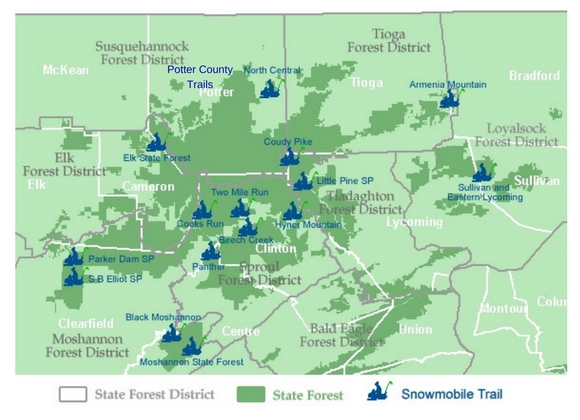
Click on the snowmobiler to pull up the map and download a printable copy. Trails are listed alphabetically below.
Armenia Mountain
Details: For details on the Forest, and its 175 miles of snowmobile trail, visit the DCNR page for Tioga State forest here. Snow conditions may be found at https://www.apps.dcnr.state.pa.us/forestry/snowmobile/northcentral.aspx
Grooming/Joint Use Roads: While Tioga Forest, District 16, encompasses 153.3 miles of joint use roads, none of these are currently posted for plowing due to gas or timber operations.
Location: Armenia Mountain Snowmobile Trail is located within Tioga State Forest. The Forest, situated primarily in Tioga County, also extends to the east into Bradford County – making up part of the North Central Region.
Beech Creek
Details: The Beech Creek snowmobile trail is located within the Sproul State Forest. For details, visit the DCNR Sproul State Forest page. Snow conditions may be found at https://www.apps.dcnr.state.pa.us/forestry/snowmobile/northcentral.aspx
Location: The Beech Creek Trail is located in Sproul State Forest, Clinton County, near the center of the 12 county region (1.5 million acres of State Forest and Game Land) designated as the “Pennsylvania Wilds” in the North Central Mountain Region.
Black Moshannon
Details: For details on the Forest, and its 168 miles of snowmobile trail, visit the DCNR Black Moshannon page. Snow conditions may be found at https://www.apps.dcnr.state.pa.us/forestry/snowmobile/northcentral.aspx
Grooming/Joint Use Roads: Moshannon State Forest District 9, encompasses 177.8 miles of joint use roads, with the following currently scheduled for possible plowing due to gas or timber operations:
| Benner Rd Buskirk Rd Colby Rd Dug Rd Firebreak Rd Gordon Rd Hannah Furnace Rd |
Horse Hollow Rd Jury Mill Rd Kelly Cellar Rd Moose Grade Shirks Rd Strawband Beaver Rd Underwood Rd |
Location: The Black Moshannon Snowmobile Trail is located within Moshannon State Forest and straddles Centre and Clearfield Counties. The Forest makes up part of the Northcentral Mountain Region.
Cooks Run
Details: For details on the Forest, visit the DCNR page for Sproul State Forest. Snow conditions may be found at https://www.apps.dcnr.state.pa.us/forestry/snowmobile/northcentral.aspx
Grooming/Joint Use Roads: Sproul State Forest, District 10, encompasses 310.4 miles of joint use roads. This season DCNR advises that the following roads may be plowed to accommodate gas & timber operations:
| Allen Dam Rd Barneys Ridge Rd Beech Creek Rd (Eagleton to Rt. 144) Big Basin Rd Carrier Rd Clubhouse Rd DeHass Rd Dry Run Rd (south) Dry Run Rd (north – Abes to Benson) Eddy Ridge Rd Fields Ridge Fisher Fire Rd Hensel Fork Rd Jews Run Rd Kato/Orviston Rd Montour Rd |
Panther Rd Pat’s Ridge Rd Penrose Rd Petes Run Rd Pfoutz Valley Rd Quarter Mile Rd Robbins Farm Rd Sandy Run Rd Shintown Run Rd Shoemaker Rd State Line Rd Trout Run Rd Sugar Camp Rd (off Kettle Creek Road) Two Mile Rd/Boyer Trail Yost Ridge Rd |
Location: The Cooks Run Division Trail is located in Sproul State Forest, Clinton County, near the center of the 12 county region (1.5 million acres of State Forest and Game Land) designated as the “Pennsylvania Wilds” in the North Central Mountain Region.
Coudy Pike
Details: For details on the Forest, and its 289 miles of snowmobile trail, visit the DCNR website for the Tiadaghton Forest. Snow conditions may be found at https://www.apps.dcnr.state.pa.us/forestry/snowmobile/northcentral.aspx
Grooming/Joint Use Roads: Tiadaghton State Forest District 12, encompasses 185.2 miles of joint use roads, though presently none are listed to be plowed for timber or oil/gas operations.
Location: The Coudy Pike Trail is located in Tiadaghton State Forest – ranging along the western side of Lycoming County and reaching north to Tioga. The Tiodaughton Forest makes up part of the Northcentral Mountain Region.
Elk State Forest
Details: For details on the Forest, and its 97 miles of snowmobile trail, visit the DCNR website for the Elk State Forest. Snow conditions may be found at:
https://www.apps.dcnr.state.pa.us/forestry/snowmobileiframe/northcentral.aspx
Grooming/Joint Use Roads: DCNR reports that Elk Forest District 13 encompasses 70.4 miles of joint use roads as part of two snowmobile trail systems located within the District.
The following roads may be plowed for gas and timber operations, and include:
Crooked Run Road
Naval Hollow Road
Ridge Road (south end to Steammill Road)
Stillhouse Road
Straight Creek Road
Wildwood Tower Road
Whitehead Road
Location: Elk State Forest is located in Cameron County, part of the Region designated as Pennsylvania Wilds. Please note for updated maps please check the PA wilds areas on the main map pages.
Hyner Mountain
Details: The trail head for the 64 mile trail is located in Hyner Run State Park running through Sproul State Forest in North Central Pennsylvania.
Location: The Hyner Mountain Trail is located in Clinton County, near the center of the 12 county region (1.5 million acres of State Forest and Game Land) designated as the “Pennsylvania Wilds” in the North Central Mountain Region.
Download printable mapLittle Pine
Details: For details on the Park, and the Tiadaghton State Forest’s 289 miles of snowmobile trail, visit the DNCR page for Tiadaghton State Forest.
Snow conditions may be found at https://www.apps.dcnr.state.pa.us/forestry/snowmobile/northcentral.aspx
Grooming/Joint Use Roads: Tiadaghton State Forest District 12, encompasses 185.2 miles of joint use roads, though presently none are listed to be plowed for timber or oil/gas operations.
Location: The Little Pine State Park Trails are located is in a mountain section of Tiadaghton State Forest – part of the Northcentral Mountain Region.
Moshannon State Forest
Details: For details on the Forest, and its 168 miles of snowmobile trail, visit the Moshannon state forest page.
Snow conditions may be found at https://www.apps.dcnr.state.pa.us/forestry/snowmobile/northcentral.aspx
Grooming/Joint Use Roads: Moshannon State Forest District 9, encompasses 177.8 miles of joint use roads, with the following currently scheduled for possible plowing due to gas or timber operations:
| Benner Rd Buskirk Rd Colby Rd Dug Rd Firebreak Rd Gordon Rd Hannah Furnace Rd |
Horse Hollow Rd Jury Mill Rd Kelly Cellar Rd Moose Grade Shirks Rd Strawband Beaver Rd Underwood Rd |
Location: Moshannon Snowmobile Trail is located within Moshannon State Forest and straddles Elk and Clearfield Counties. The Forest makes up part of the Northcentral Mountain Region.
Download Printable Map
North Central
Details: Snow conditions may be found at https://www.apps.dcnr.state.pa.us/forestry/snowmobile/northcentral.aspx
Grooming/Joint Use Roads: Susquehannock State Forest District 15 encompasses 145.8 miles of joint use roads, with the following currently scheduled for possible plowing due to gas or timber operations:
| Bailey Run Road Gaswell Road Hungry Hollow Joerg Road Junction Road Little Moores Run Road Long Run Trail Marvin Run Road |
McConnell Road Nelson Run Road Portage Road Spring Brook Road Sunken Branch Road to Lyman Run Thompson Hollow Rd (Ridge Rd to Rt 6) Twelve Mile Road Wildcat Trail |
Tioga Forest District 16 encompasses 153.3 miles of joint use road. At this time none appear to be scheduled for plowing.
Location: The North Central Snowmobile Trail is located within Potter and Tioga County, in the north central portion of the 12 county region (1.5 million acres of State Forest and Game Land) designated as the “Pennsylvania Wilds”, North Central Mountain Region.
Panther
Details: The Panther trail is located within the Sproul State Forest. Snow conditions may be found at https://www.apps.dcnr.state.pa.us/forestry/snowmobile/northcentral.aspx
Grooming/Joint Use Roads: Sproul State Forest, District 10, encompasses 310.4 miles of joint use roads.
DCNR advises that the some roads may be plowed to accommodate gas & timber operations.
Location: The Panther Trail is located in Sproul State Forest, at the western edge of Clinton County, within the 12 county region (1.5 million acres of State Forest and Game Land) designated as the “Pennsylvania Wilds” in the North Central Mountain Region.
Parker Dam
Details: For details on the Forest, visit the DCNR Moshannon page.
Snow conditions may be found at https://www.apps.dcnr.state.pa.us/forestry/snowmobile/northcentral.aspx
Grooming/Joint Use Roads: Moshannon State Forest, District 9, encompasses 177.8 miles of joint use roads. This season DCNR advises that within the Forest, the following roads may be plowed to accommodate timber and gas operations:
| Benner Rd Buskirk Rd Colby Rd Dug Rd Firebreak Rd Gordon Rd Hannah Furnace Rd |
Horse Hollow Rd Jury Mill Rd Kelly Cellar Rd Moose Grade Shirks Rd Strawband Beaver Rd Underwood Rd |
Location: The Parker Dam State Park Trail is located within Moshannon State Forest, Clearfield County, and situated in the southwest quadrant of the 12 county region (1.5 million acres of State Forest and Game Land) designated as the “Pennsylvania Wilds” in the North Central Mountain Region.
Potter County Trails
Details: Snow conditions may be found at Trail Conditions.com
Grooming/Joint Use Roads: Potter County encompasses 145.8 miles of joint use roads, with the following currently scheduled for possible plowing due to gas or timber operations:
| Bailey Run Road Gaswell Road Hungry Hollow Joerg Road Junction Road Little Moores Run Road Long Run Trail Marvin Run Road |
McConnell Road Nelson Run Road Portage Road Spring Brook Road Sunken Branch Road to Lyman Run Thompson Hollow Rd (Ridge Rd to Rt 6) Twelve Mile Road Wildcat Trail |
Tioga Forest District 16 encompasses 153.3 miles of joint use road. At this time none appear to be scheduled for plowing.
See other Trail Info for this area Here
Location:Located just outside of Couldersport, Pa on Rt 6. This is one of the largest areas in PA for snowmobile riding. It also has Quad trails in the summer months as well. See the DCNR page for those trails. This area also runs to near the PA Grand Canyon as well. This is one of the longest riding areas in PA with good snow coverage when many other places have none. See the Web cams in North Central PA for those conditions.
SB Elliott
Details: For details on the Forest, and its 168 miles of snowmobile trail, visit the DCNR page for Moshannon State park. Park information may be found at the DCNR Page for SB Elliott State park.
And snow conditions at https://www.dcnr.state.pa.us/forestry/snowmobile/northcentral.aspxGrooming/Joint Use Roads: Moshannon State Forest District 9, encompasses 177.8 miles of joint use roads with some scheduled for closures this winter.
Location: The SB Elliot State Park Snowmobile Trail is located within Moshannon State Forest in Clearfield County and situated in the southwest quadrant of the 12 county region (1.5 million acres of State Forest and Game Land) designated as the “Pennsylvania Wilds” in the North Central Mountain Region.
Sullivan and East Lycoming
Details: For details on the Forest, and its 121 miles of snowmobile trail, visit the DCNR page for Loyalsock State park.
Snow conditions may be found at https://www.dcnr.state.pa.us/forestry/snowmobile/northcentral.aspx.
Grooming/Joint Use Roads: Loyalsock State Forest District 20, encompasses 115 miles of joint use roads, with the following currently scheduled for possible plowing due to gas or timber operations:
Big Hollow Road
East End of Little Bear Road
Grays Run Road
Brown Road
East end of Pleasant Stream Road
Mill Creed Road
Two Mile Run
Details: For details on Two Mile Run, visit the DCRN page for Sproul State Forest. Snow conditions may be found at https://www.apps.dcnr.state.pa.us/forestry/snowmobile/northcentral.aspxGrooming/Joint Use Roads: Sproul State Forest, District 10, encompasses 310.4 miles of joint use roads. This season DCNR advises that the following roads may be plowed to accommodate gas & timber operations:
| Allen Dam Rd Barneys Ridge Rd Beech Creek Rd (Eagleton to Rt. 144) Big Basin Rd Carrier Rd Clubhouse Rd DeHass Rd Dry Run Rd (south) Dry Run Rd (north – Abes to Benson) Eddy Ridge Rd Fields Ridge Fisher Fire Rd Hensel Fork Rd Jews Run Rd Kato/Orviston RdMontour Rd |
Panther Rd Pat’s Ridge Rd Penrose Rd Petes Run Rd Pfoutz Valley Rd Quarter Mile Rd Robbins Farm Rd Sandy Run Rd Shintown Run Rd Shoemaker Rd State Line Rd Trout Run Rd Sugar Camp Rd (off Kettle Creek Road) Two Mile Rd/Boyer Trail Yost Ridge Rd |
Location: Two Mile Run is located in Sproul State Forest, Clinton County, near the center of the 12 county region (1.5 million acres of State Forest and Game Land) designated as the “Pennsylvania Wilds” in the North Central Mountain Region.
