PA State Snowmobile Association

  • Facebook
  • Instagram
  • Home
  • Ride PA
    • PA Snowmobiling Requirements
      • Snowmobile Laws In PA
      • PA Snowmobile Registration
      • Reciprocity
    • Safety
      • Snowmobile Safety Classes
    • Seasonal Information
      • Trail News
      • Sled Maintenance
    • PA Snowmobile Registration
  • Trail Maps
    • Allegheny National Forest
    • Erie Region
    • Central and Southcentral Mountains
    • Laurel Highlands
    • Northcentral Mountains
    • Pocono and Eastcentral Mountains
    • Snow Trails TV
  • Webcams
  • Directories
    • Pennsylvania Clubs
    • Out of State Clubs
    • Dealers & Accessory Dealers
    • Travel and Tourism
  • Membership
    • Join
    • Donate
    • Member Login
    • Membership Benefits
      • Member Discounts
      • Benefits for Clubs
      • Benefits for Business Members
    • Renew Your Membership
    • Meet Your Regional Directors
  • Programs
    • Events
    • PA Powersports Show
    • Snow Angels
    • Signs
    • Grooming
    • Trail Grants
    • Trail Inventory
    • Intersection Sign Pilot
  • News
    • Keystone Snowmobiler
      • Advertise With PSSA
    • President’s Message
    • ACSA
  • About
    • Board of Directors
      • Board Committees
    • Contact Us
    • Annual Awards
    • Advertising Opportunities

Northcentral Mountains

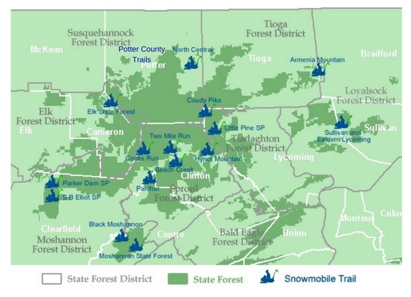
Click on the snowmobiler to pull up the map and download a printable copy. Trails are listed alphabetically below.

Map showing snowmobile trail locations within the northcentral mountains region of Pennsylvania

Armenia Mountain

Two Mile Run

Sullivan & East Lycoming

SB Elliot

Potter County Trails

Parker Dam

Panther

North Central

Little Pine

Hyner Mountain

Elk State Forest

Coudy Pike

Cooks Run

Beech Creek

Black Moshannon

Moshannon State Forest

09/26/2016 by PSSA

Two Mile Run

Details: For details on Two Mile Run, visit the DCRN page for Sproul State Forest. Snow conditions may be found at http://www.apps.dcnr.state.pa.us/forestry/snowmobile/northcentral.aspxGrooming/Joint Use Roads: Sproul State Forest, District 10, encompasses 310.4 miles of joint use roads. This season DCNR advises that the following roads may be plowed to accommodate gas & timber operations: Allen Dam Rd Barneys Ridge […]

Filed Under: Maps, Northcentral Mountains

  • « Previous Page
  • 1
  • 2
  • 3
  • 4

Keystone Snowmobiler Magazine

Allegheny National Forest

Allegheny National Forest

Erie Region

Erie County Trails

Central and Southcentral Mountains

Babcock

Bald Eagle North

Bald Eagle South

More Trails from this Region

Laurel Highlands

Laurel Highlands North

Laurel Highlands South

More Trails from this Region

Northcentral Mountains

Armenia Mountain

Beech Creek

Black Moshannon

More Trails from this Region

Pocono and Eastcentral Region

Delaware/Promised Land

Dixon Miller

Edgemere Pecks Pond

More Trails from this Region

Serving Snowmobilers in PA

PSSA is a statewide membership organization committed to enhancing the Pennsylvania snowmobiling experience of family recreation, fellowship, and tourism, by striving to assure high quality trails and safe, environmentally-responsible recreational use of snowmobiles.

Snowmobiling in PA! Click on the image for more information!

PSSA Board Meetings

PSSA holds a monthly meeting of the Board & Regional Directors on the 3rd Wednesday of each month at 7:30pm. Members are invited to attend. Please email member@pasnow.org to receive the meeting credentials and indicate if you have a question or concern that you would like to see addressed at a meeting.

  • Keystone Snowmobiler
  • Trail Maps & Videos
  • Webcams
  • Contact Us
  • Refund Policy
  • Privacy Policy

Copyright © 2023 · WordPress · Log in